Thanksgiving Roadtrip
Thanksgiving weekend we went on a little roadtrip. We left Saturday morning bright and early at 8am and drove east. Here's a map of our route:
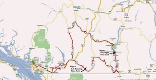
Saturday: Left Vancouver, drove through Hope where we stopped at the visitor center and got a lot of pamphlets (I loooove pamphlets). We then stopped for a little hike where the old Kettle Valley Railway used to go through; it was torn down in the 60's. It was built in a canyon and the workers had to blast through rock to create a series of tunnels for the trains to drive through. This was the easiest area to build the railway to connect the east and west. Apparently it also had passenger cars but it only travelled at night because the passage was considered too scary for the passengers!
After that, we drove to Manning Provincial Park where we went on a mini hike and then camped the night.
Sunday: We woke up to rain and snow!!! After breakfast, we packed up the car and kept on driving east. We stopped in Headley, a very very very small town. The only reason this town was even there was because of a mine that was built in the early 1900's. The mine is now closed and we estimated about a couple of hundred people live there now. The tourist office/museum/tea room/souvenir shop sold maps of the town for self-guided historical tours of the town so we bought one and it took us about 30mins to walk around the WHOLE town. After the tour - back in the car heading east. Did you know that as you drive east in southern BC the environment gets more and more desert-like? It was really odd to be driving through mountains full of pine trees and rock, then through rolling grassy hills to end up driving through Osoyoos BC in the desert. And when we say desert - we mean desert. It lookes like Arizona with a couple of pine trees here and there in the hills! This desert also comes complete with rattlesnacks, sagebrush and cacti. Who knew?
This, my friends, is the southern most point of the famous Okanagan Valley where great wine and most of our produce comes from. That night we camped in a park at the edge of the Okanagan Lac.
Monday: Woke up, packed up the car and now headed north. We drove to a town called Peachland, which is just south of Kelowna. Stopped at Tim Horton's for coffee and a self-administered breakfast sandwhich taste test (by the way: they're really good!) and started our journey back west to a town called Lytton, which is where the Thompson river meets the Fraser river. We also noted that this area has the highest train traffic of anywhere! There is a CN rail line on one side of the river and a Pacific Railway line on the other and there are at least 1 train on each track passing through the town at all times! And in case you didn't know - Tom loves trains. We spent a long long long time watching the trains go by...
After Lytton, we commenced our journey home south through the Fraser Valley.
Another successful weekend trip!
Check out our pics: PHOTO ALBUM
Thanksgiving weekend we went on a little roadtrip. We left Saturday morning bright and early at 8am and drove east. Here's a map of our route:
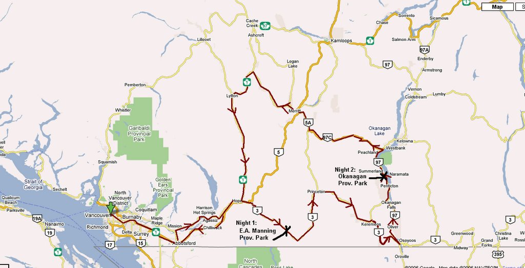
Saturday: Left Vancouver, drove through Hope where we stopped at the visitor center and got a lot of pamphlets (I loooove pamphlets). We then stopped for a little hike where the old Kettle Valley Railway used to go through; it was torn down in the 60's. It was built in a canyon and the workers had to blast through rock to create a series of tunnels for the trains to drive through. This was the easiest area to build the railway to connect the east and west. Apparently it also had passenger cars but it only travelled at night because the passage was considered too scary for the passengers!
After that, we drove to Manning Provincial Park where we went on a mini hike and then camped the night.
Sunday: We woke up to rain and snow!!! After breakfast, we packed up the car and kept on driving east. We stopped in Headley, a very very very small town. The only reason this town was even there was because of a mine that was built in the early 1900's. The mine is now closed and we estimated about a couple of hundred people live there now. The tourist office/museum/tea room/souvenir shop sold maps of the town for self-guided historical tours of the town so we bought one and it took us about 30mins to walk around the WHOLE town. After the tour - back in the car heading east. Did you know that as you drive east in southern BC the environment gets more and more desert-like? It was really odd to be driving through mountains full of pine trees and rock, then through rolling grassy hills to end up driving through Osoyoos BC in the desert. And when we say desert - we mean desert. It lookes like Arizona with a couple of pine trees here and there in the hills! This desert also comes complete with rattlesnacks, sagebrush and cacti. Who knew?
This, my friends, is the southern most point of the famous Okanagan Valley where great wine and most of our produce comes from. That night we camped in a park at the edge of the Okanagan Lac.
Monday: Woke up, packed up the car and now headed north. We drove to a town called Peachland, which is just south of Kelowna. Stopped at Tim Horton's for coffee and a self-administered breakfast sandwhich taste test (by the way: they're really good!) and started our journey back west to a town called Lytton, which is where the Thompson river meets the Fraser river. We also noted that this area has the highest train traffic of anywhere! There is a CN rail line on one side of the river and a Pacific Railway line on the other and there are at least 1 train on each track passing through the town at all times! And in case you didn't know - Tom loves trains. We spent a long long long time watching the trains go by...
After Lytton, we commenced our journey home south through the Fraser Valley.
Another successful weekend trip!
Check out our pics: PHOTO ALBUM
posted by Marie & Tom at
2:09 PM
![]()
